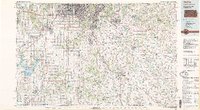
1983 Map of Olathe
USGS Topo · Published 1984About this map
The historical Santa Fe Trail cuts across the suburban landscape of the early 1980s, bridging the gap between the burgeoning growth of Kansas City and the rural reaches of the Kansas-Missouri border. This survey captures a pivotal moment of expansion as cities like Overland Park, Olathe, and Lee's Summit coalesce into a regional corridor. Major educational and military anchors define the era, notably Mid-America Nazarene College and the strategic presence of Richards-Gebaur Air Force Base.
Find a feature on this map
85 named features on this map. Tap any name to fly to it.
Don’t see what you’re looking for? This feature index may not catch every label — zoom into the map to look around manually.
Map Details
Editions of this 1983 Olathe Map
This is the sole edition of this map. No revisions or reprints were ever made.
Other maps of this area
1885 · Garnett
USGS Topo · 1:125,000
1885 · Warrensburg
USGS Topo · 1:125,000
1885 · Lawrence
USGS Topo · 1:125,000

1886 · Oskaloosa
USGS Topo · 1:125,000
1887 · Clinton
USGS Topo · 1:125,000

1887 · Harrisonville
USGS Topo · 1:125,000

1887 · Olathe
USGS Topo · 1:125,000
1887 · Butler
USGS Topo · 1:125,000
1887 · Mound City
USGS Topo · 1:125,000
1887 · Warrensburg
USGS Topo · 1:125,000