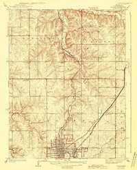
1943 Map of Olathe
USGS Topo · Published 1943About this map
The street grid of Olathe sits at the nexus of a bustling mid-century rail corridor, where the Atchison Topeka and Santa Fe and the St Louis and San Francisco railroads converge. Surveyed in the 1930s, the landscape is defined by its rural school districts and local landmarks like the Summerfield Grange Hall and the County Farm. Small settlements such as Monticello and Craig are anchored by neighborhood institutions, including the Monticello Ch and a network of schools like Shiloh Sch and Prairie Star Sch. The terrain is deeply etched by Mill Creek and Cedar Creek, which separate the uplands from the growing urban center. This 1943 edition documents the transition from a traditional farming community to a regional hub, evidenced by the presence of a Sewage Disposal facility and the clearly defined borders of the Monticello and Shawnee townships.
Find a feature on this map
30 named features on this map. Tap any name to fly to it.
Don’t see what you’re looking for? This feature index may not catch every label — zoom into the map to look around manually.
Map Details
Editions of this 1943 Olathe Map
3 editions found

Other maps of this area

1887 · Olathe
USGS Topo · 1:125,000

1890 · Kansas City
USGS Topo · 1:125,000

1893 · Olathe
USGS Topo · 1:125,000

1894 · Kansas City
USGS Topo · 1:125,000

1934 · Bonner Springs
USGS Topo · 1:48,000

1934 · Shawnee
USGS Topo · 1:24,000

1934 · Edwardsville
USGS Topo · 1:24,000

1935 · Olathe
USGS Topo · 1:24,000

1935 · Lenexa
USGS Topo · 1:24,000

1940 · Bonner Springs
USGS Topo · 1:62,500