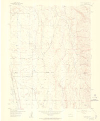
1955 Map of Olathe NW
USGS Topo · Published 1956About this map
Irrigation infrastructure and aviation dominate the high desert landscape of Delta and Montrose Counties in the mid-1950s. The western edge of the map is defined by the Uncompahgre River and the tracks of the Denver and Rio Grande Western railroad, which parallel the river's course. This area serves as a transport corridor for the region's agricultural output, supported by an extensive network of water management features.
Find a feature on this map
20 named features on this map. Tap any name to fly to it.
Don’t see what you’re looking for? This feature index may not catch every label — zoom into the map to look around manually.
Map Details
Editions of this 1955 Olathe NW Map
5 editions found
Other maps of this area

1955 · Olathe NW
USGS Topo · 1:24,000

1955 · Black Ridge
USGS Topo · 1:24,000

1955 · Olathe
USGS Topo · 1:24,000

1955 · Red Rock Canyon
USGS Topo · 1:24,000

1955 · Lazear
USGS Topo · 1:24,000

1956 · Montrose
USGS Topo · 1:250,000

1956 · Moab
USGS Topo · 1:250,000

1959 · Moab
USGS Topo · 1:250,000

1959 · Montrose
USGS Topo · 1:250,000

1960 · Montrose
USGS Topo · 1:250,000