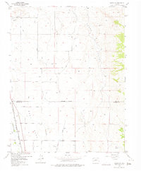
1955 Map of Olathe NW
USGS Topo · Published 1975About this map
Agricultural development along the Uncompahgre River defines this mid-century landscape on the border of Delta and Montrose Counties. A complex network of irrigation infrastructure, including the Selig Canal, East Canal, and numerous instances of the Ditch label, illustrates the intensive water management required to farm the arid terrain surrounding East Mesa. The map records several water control structures such as the Lower Peach Valley Dam and Peach Valley Dam No 1 within the prominent Peach Valley. Transportation and utility corridors are represented by the Denver and Rio Grande Western railroad line and the Star Nelson Airport in the northwest. This survey provides a precise look at the rural canyon-and-mesa geography before more modern expansion, highlighting features like the Loutsenhizer Arroyo and the high ground of Black Ridge.
Find a feature on this map
19 named features on this map. Tap any name to fly to it.
Don’t see what you’re looking for? This feature index may not catch every label — zoom into the map to look around manually.
Map Details
Editions of this 1955 Olathe NW Map
5 editions found
Other maps of this area

1955 · Olathe NW
USGS Topo · 1:24,000

1955 · Black Ridge
USGS Topo · 1:24,000

1955 · Olathe
USGS Topo · 1:24,000

1955 · Red Rock Canyon
USGS Topo · 1:24,000

1955 · Lazear
USGS Topo · 1:24,000

1956 · Montrose
USGS Topo · 1:250,000

1956 · Moab
USGS Topo · 1:250,000

1959 · Moab
USGS Topo · 1:250,000

1959 · Montrose
USGS Topo · 1:250,000

1960 · Montrose
USGS Topo · 1:250,000