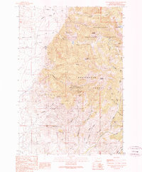
1989 Map of Old Baldy Mountain
USGS Topo · Published 1989About this map
Mining claims and high-altitude terrain dominate the boundary between the Beaverhead National Forest and Deerlodge National Forest during the late 1980s. The landscape is a network of named prospects and workings, including the Eleanora Mines and Argenta Mine, which are situated along the complex drainages of Goodrich Gulch. These operations, along with others like the Moffat Mine and Corncracker Mine, reflect a deep history of extraction in this corner of Madison County.
Find a feature on this map
45 named features on this map. Tap any name to fly to it.
Don’t see what you’re looking for? This feature index may not catch every label — zoom into the map to look around manually.
Map Details
Editions of this 1989 Old Baldy Mountain Map
This is the sole edition of this map. No revisions or reprints were ever made.
Other maps of this area

1893 · Dillon
USGS Topo · 1:250,000

1955 · Dillon
USGS Topo · 1:250,000

1957 · Dillon
USGS Topo · 1:250,000

1958 · Dillon
USGS Topo · 1:250,000

1960 · Twin Bridges
USGS Topo · 1:62,500

1960 · Waterloo
USGS Topo · 1:62,500

1962 · Dillon
USGS Topo · 1:250,000
1962 · Beaverhead Rock NE
USGS Topo · 1:24,000
1963 · Sheridan
USGS Topo · 1:24,000
1963 · Copper Mountain
USGS Topo · 1:24,000