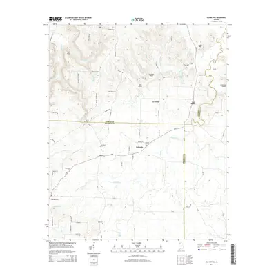
2014 Map of Old Bethel
USGS Topo · Published 2014About this map
La Grange and the surrounding plateau of Northwest Alabama are defined by a complex network of hollows and ridges where the boundaries of Colbert, Franklin, and Lawrence counties converge. This 2014 survey reveals a landscape deeply connected to its early settlers, evidenced by numerous family burying grounds such as Gargis Cem, Sibley Cem, and Pennington Cem. The topography is marked by named drainages like Bull Skull Cr and Little Mud Cr, which carve through the terrain near McCorkles Gap. Small communities like Old Bethel and Saints Crossroads serve as local hubs, connected by a web of county roads and trails like Piney Woods Trl. The inclusion of landmarks such as Bean Bridge and Gin House Hollow provides specific geographic anchors for genealogists and local historians tracking the development of these rural townships.
Find a feature on this map
90 named features on this map. Tap any name to fly to it.
Don’t see what you’re looking for? This feature index may not catch every label — zoom into the map to look around manually.
Map Details
Editions of this 2014 Old Bethel Map
This is the sole edition of this map. No revisions or reprints were ever made.
Other maps of this area

1924 · Tuscumbia
USGS Topo · 1:48,000

1926 · Tuscumbia
USGS Topo · 1:62,500

1936 · Russellville
USGS Topo · 1:24,000

1936 · Newburg
USGS Topo · 1:24,000

1936 · Moulton
USGS Topo · 1:48,000

1936 · Spruce Pine
USGS Topo · 1:24,000

1936 · Town Creek
USGS Topo · 1:24,000
1936 · Leighton
USGS Topo · 1:24,000
1936 · Tuscumbia
USGS Topo · 1:24,000

1936 · Hatton
USGS Topo · 1:24,000