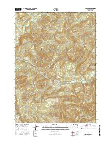
2017 Map of Old Fairview
USGS Topo · Published 2017About this map
The North Umpqua River carves through the heart of this Douglas County landscape, serving as a central geographic anchor for a network of forest roads and topographic landmarks. Near the northern boundary, the lookout at Old Fairview stands over a series of drainage basins, including those of Rock Creek and Miller Cr. This 2017 survey details a highly managed forest environment, defined by an intricate web of timber access routes such as Conley Cr Old Tie and Swiftwater Tie. High points like Chimney Rock, Shivigny Mtn, and Bob Butte dominate the interior, while the Paris Reservoir sits near the eastern edge. Local-history value is found in the specific naming of these springs and ridges, such as Thunder Ridge Sp and Smith Ford Sp, which reveal the long-standing use of the terrain for transit and resource management.
Find a feature on this map
86 named features on this map. Tap any name to fly to it.
Don’t see what you’re looking for? This feature index may not catch every label — zoom into the map to look around manually.
Map Details
Editions of this 2017 Old Fairview Map
This is the sole edition of this map. No revisions or reprints were ever made.
Other maps of this area

1897 · Roseburg
USGS Topo · 1:125,000

1900 · Roseburg
USGS Topo · 1:125,000
1954 · Dixonville
USGS Topo · 1:62,500
1954 · Glide
USGS Topo · 1:62,500
1955 · Red Butte
USGS Topo · 1:62,500
1955 · Mace Mtn
USGS Topo · 1:62,500

1958 · Roseburg
USGS Topo · 1:250,000

1959 · Roseburg
USGS Topo · 1:250,000
1978 · Diamond Lake
USGS Topo · 1:100,000
1979 · Roseburg
USGS Topo · 1:100,000