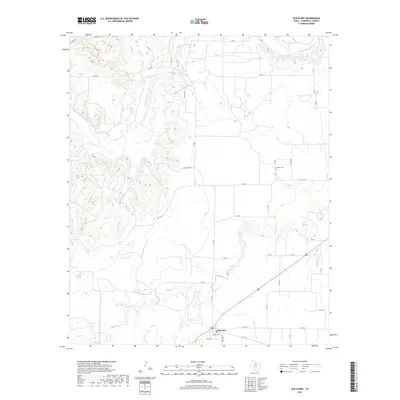
2019 Map of Old Glory
USGS Topo · Published 2019About this map
The Salt Fork Brazos River winds through the northern portion of this Stonewall County landscape, carving a complex network of drainage basins. Numerous seasonal streams, including Wilfong Cr, Turkey Roost Cr, and Rockhouse Cr, feed into the river system from the south, creating a dissected terrain. The small community of Old Glory sits at the intersection of FM 1835 and highway 380, serving as the primary anchor for this rural Texas region. Genealogists and local researchers will find the Hooker Cem located further north along C R 253, a site that remains an important local landmark. The map illustrates a grid of county roads and private trails, such as Co RD 132 and Co RD 239, which facilitate movement across the cattle ranching and farming country surrounding Tonk Creek.
Find a feature on this map
38 named features on this map. Tap any name to fly to it.
Don’t see what you’re looking for? This feature index may not catch every label — zoom into the map to look around manually.
Map Details
Editions of this 2019 Old Glory Map
This is the sole edition of this map. No revisions or reprints were ever made.
Other maps of this area

1925 · Aspermont 4-a
USGS Topo · 1:48,000

1925 · Haskell 3-b
USGS Topo · 1:48,000

1931 · Aspermont
USGS Topo · 1:62,500

1954 · Lubbock
USGS Topo · 1:250,000

1954 · Wichita Falls
USGS Topo · 1:250,000

1958 · Wichita Falls
USGS Topo · 1:250,000

1962 · Kiowa Peak
USGS Topo · 1:24,000
1962 · Frog Mountain
USGS Topo · 1:24,000

1964 · Sagerton
USGS Topo · 1:24,000

1965 · Jud
USGS Topo · 1:24,000