
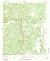
1962 Map of Kiowa Peak
USGS Topo · Published 1966About this map
Kiowa Peak and Davidson Peak dominate the topography of this Stonewall County landscape, marking a rugged terrain where several major watercourses converge. In the early 1960s, the Brazos River is joined by the Salt Fork Brazos River and the Double Mountain Fork, creating a complex drainage network carved by deep cuts like Smelter Canyon and Panther Canyon. The mapping reveals a sparse, industrial presence in this part of Texas, characterized by scattered wells and a significant pipeline cutting across the northern reaches.
Find a feature on this map
16 named features on this map. Tap any name to fly to it.
Don’t see what you’re looking for? This feature index may not catch every label — zoom into the map to look around manually.
Map Details
Editions of this 1962 Kiowa Peak Map
2 editions found
Other maps of this area

1925 · Aspermont 4-a
USGS Topo · 1:48,000

1925 · Haskell 3-b
USGS Topo · 1:48,000

1931 · Aspermont
USGS Topo · 1:62,500

1954 · Lubbock
USGS Topo · 1:250,000

1954 · Wichita Falls
USGS Topo · 1:250,000

1958 · Wichita Falls
USGS Topo · 1:250,000

1965 · Jud
USGS Topo · 1:24,000

1967 · Knox City NW
USGS Topo · 1:24,000

1967 · Kiowa Peak NW
USGS Topo · 1:24,000

1967 · Kiowa Peak NE
USGS Topo · 1:24,000