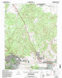
1994 Map of Old Mammoth
USGS Topo · Published 1997About this map
Inyo National Forest surrounds the growing community of Mammoth Lakes in this mid-1990s survey. The map details the developed core of the town, featuring civic essentials such as the Hospital, Post Office, and St Joseph Church, alongside recreation-focused sites like the Mammoth Visitor Center and Shady Rest campgrounds. To the south, the original settlement of Old Mammoth remains distinct, nestled near the banks of Mammoth Creek at the base of the mountains.
Find a feature on this map
37 named features on this map. Tap any name to fly to it.
Don’t see what you’re looking for? This feature index may not catch every label — zoom into the map to look around manually.
Map Details
Editions of this 1994 Old Mammoth Map
This is the sole edition of this map. No revisions or reprints were ever made.
Other maps of this area

1901 · Mt. Lyell
USGS Topo · 1:125,000

1914 · Mt. Morrison
USGS Topo · 1:125,000

1947 · Mariposa
USGS Topo · 1:250,000

1948 · Mariposa
USGS Topo · 1:250,000

1953 · Mt. Morrison
USGS Topo · 1:62,500

1953 · Mono Craters
USGS Topo · 1:62,500

1953 · Devils Postpile
USGS Topo · 1:62,500

1957 · Mariposa
USGS Topo · 1:250,000

1962 · Cowtrack Mtn
USGS Topo · 1:62,500

1963 · Mariposa
USGS Topo · 1:250,000