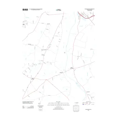
2013 Map of Old Sparta
USGS Topo · Published 2013About this map
The Tar River meanders through this portion of the Coastal Plain, serving as a historic axis for early transportation and riverfront activity. Nearby, Suggs Landing and the Cromwell Canal reflect the drainage and navigation efforts characteristic of this low-lying landscape. The settlement pattern is defined by several rural crossroads, including Old Sparta and Scotts Crossroads, which emerged at the intersections of vital transit routes. These hamlets, along with Penny Hill and Suggs Crossroads, reveal a community structure based on agricultural commerce and river access. Local drainage is supported by numerous small tributaries like Jerrys Cr and Bynum Mill Cr, while Winslows Pond and Hokes Pond offer evidence of water management and recreation in the area. This 2013 snapshot preserves the rural layout of Edgecombe County before further modern development modified the land.
Find a feature on this map
88 named features on this map. Tap any name to fly to it.
Don’t see what you’re looking for? This feature index may not catch every label — zoom into the map to look around manually.
Map Details
Editions of this 2013 Old Sparta Map
This is the sole edition of this map. No revisions or reprints were ever made.
Other maps of this area

1901 · Parmele
USGS Topo · 1:62,500

1902 · Parmele
USGS Topo · 1:62,500

1902 · Tarboro
USGS Topo · 1:62,500

1903 · Tarboro
USGS Topo · 1:62,500

1903 · Winterville
USGS Topo · 1:62,500

1904 · Falkland
USGS Topo · 1:62,500

1905 · Winterville
USGS Topo · 1:62,500

1953 · Rocky Mount
USGS Topo · 1:250,000

1954 · Rocky Mount
USGS Topo · 1:250,000
1980 · Pinetops
USGS Topo · 1:24,000