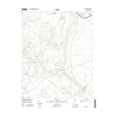
2016 Map of Old Sparta
USGS Topo · Published 2016About this map
The Tar River winds through this coastal plain landscape south of Tarboro, defining the movement of water and settlement patterns in Edgecombe County. Small rural communities like Old Sparta, Henrietta, and Davistown are connected by a network of farm roads, including Colonial Rd and Woodland Rd. The topography is marked by significant drainage features such as the Cromwell Canal and Knight Canal, which intersect with natural branches like Cheeks Mill Cr and Bynum Mill Cr. Near the northern boundary, the settlement of Princeville sits along the river, while Penny Hill marks the southern reach near the border with Pitt County. Local history is anchored by landmarks like the Greenwood Cem and family-named routes such as Joyner Farm Rd and Harrell Farm Ln, reflecting a landscape deeply tied to its agricultural roots.
Find a feature on this map
61 named features on this map. Tap any name to fly to it.
Don’t see what you’re looking for? This feature index may not catch every label — zoom into the map to look around manually.
Map Details
Editions of this 2016 Old Sparta Map
This is the sole edition of this map. No revisions or reprints were ever made.
Other maps of this area

1901 · Parmele
USGS Topo · 1:62,500

1902 · Parmele
USGS Topo · 1:62,500

1902 · Tarboro
USGS Topo · 1:62,500

1903 · Tarboro
USGS Topo · 1:62,500

1903 · Winterville
USGS Topo · 1:62,500

1904 · Falkland
USGS Topo · 1:62,500

1905 · Winterville
USGS Topo · 1:62,500

1953 · Rocky Mount
USGS Topo · 1:250,000

1954 · Rocky Mount
USGS Topo · 1:250,000
1980 · Pinetops
USGS Topo · 1:24,000