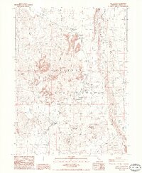
1985 Map of Old Station
USGS Topo · Published 1985About this map
Old Station and its namesake post office serve as the primary human touchpoints in this rugged volcanic landscape within the Lassen National Forest. The map illustrates a high-desert environment dominated by lava flows and geological landmarks such as Subway Cave, Ice Cave, and the prominent Sugarloaf Peak. Water is a defining element for both recreation and geography, with Hat Creek carving through the Hat Creek Valley and feeding sites like Big Spring and Baker Lake. This 1985 edition documents a well-developed recreational infrastructure, featuring numerous public sites like Rocky Campground, Bridge Picnic Area, and Old Station Picnic Area. For hikers and researchers of modern land use, the route of the Pacific National Scenic Trail is clearly delineated as it traverses the eastern edge along the Hat Creek Rim, highlighting the area's importance as a corridor for wilderness travel.
Find a feature on this map
37 named features on this map. Tap any name to fly to it.
Don’t see what you’re looking for? This feature index may not catch every label — zoom into the map to look around manually.
Map Details
Editions of this 1985 Old Station Map
2 editions found
Other maps of this area

1886 · Lassen Peak
USGS Topo · 1:250,000

1892 · Lassen Peak
USGS Topo · 1:250,000

1894 · Lassen Peak
USGS Topo · 1:250,000

1935 · Burney
USGS Topo · 1:96,000

1939 · Burney
USGS Topo · 1:125,000

1939 · Halls Flat
USGS Topo · 1:125,000

1955 · Westwood
USGS Topo · 1:250,000

1956 · Manzanita Lake
USGS Topo · 1:62,500

1957 · Prospect Peak
USGS Topo · 1:62,500

1957 · Burney
USGS Topo · 1:62,500