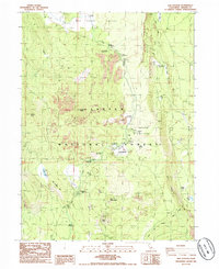
1985 Map of Old Station
USGS Topo · Published 1985About this map
Old Station serves as the central hub of this northern California landscape, situated where the volcanic topography of the Lassen National Forest meets the distinct Hat Creek Rim. The map documents a recreational and geological crossroads, most notably featuring the underground passage of Subway Cave and the boulder-strewn expanse of Devils Half Acre. This mid-1980s survey illustrates a landscape heavily defined by its volcanic history, with labels for numerous lava flows surrounding prominent heights like Sugarloaf Peak and Wilcox Peak.
Find a feature on this map
36 named features on this map. Tap any name to fly to it.
Don’t see what you’re looking for? This feature index may not catch every label — zoom into the map to look around manually.
Map Details
Editions of this 1985 Old Station Map
2 editions found
Other maps of this area

1886 · Lassen Peak
USGS Topo · 1:250,000

1892 · Lassen Peak
USGS Topo · 1:250,000

1894 · Lassen Peak
USGS Topo · 1:250,000

1935 · Burney
USGS Topo · 1:96,000

1939 · Burney
USGS Topo · 1:125,000

1939 · Halls Flat
USGS Topo · 1:125,000

1955 · Westwood
USGS Topo · 1:250,000

1956 · Manzanita Lake
USGS Topo · 1:62,500

1957 · Prospect Peak
USGS Topo · 1:62,500

1957 · Burney
USGS Topo · 1:62,500