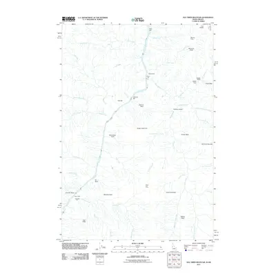
2011 Map of Old Timer Mountain
USGS Topo · Published 2011About this map
The Snake River carves a deep path through this Idaho landscape, serving as a primary corridor for small settlements and ranching outposts along its banks. The terrain is marked by numerous bars and landings, including Fine Bar, Pony Bar, and Johnson Bar, which historically provided access points in this steep river canyon. Named locations like McLeod Ranch and the Wilson Cow Camp suggest a history of seasonal grazing and remote habitation, while scattered shelters such as the McGaffee Cabin and Wilson Cabin are found near the confluence of side streams like Bernard Creek and Sluice Creek. High above the river, the topography rises to the summit of Old Timer Mountain and the prominent Indian Trail Ridge, where the landscape is defined by drainage basins like Cougar Basin and McGaffee Basin. The distribution of these family-named landmarks reflects the localized scale of exploration and land use in this part of Idaho County.
Find a feature on this map
51 named features on this map. Tap any name to fly to it.
Don’t see what you’re looking for? This feature index may not catch every label — zoom into the map to look around manually.
Map Details
Editions of this 2011 Old Timer Mountain Map
This is the sole edition of this map. No revisions or reprints were ever made.
Other maps of this area

1922 · He Devil
USGS Topo · 1:48,000

1938 · Riggins
USGS Topo · 1:96,000

1945 · Riggins
USGS Topo · 1:125,000

1954 · Kernan Point
USGS Topo · 1:62,500

1955 · Grangeville
USGS Topo · 1:250,000

1957 · He Devil
USGS Topo · 1:62,500

1959 · Grangeville
USGS Topo · 1:250,000

1963 · Kirkwood Creek
USGS Topo · 1:24,000
1964 · Kessler Creek
USGS Topo · 1:24,000
1964 · Heavens Gate
USGS Topo · 1:24,000