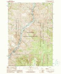
1990 Map of Old Timer Mtn.
USGS Topo · Published 1990About this map
Snake River rapids define the boundary between Oregon and Idaho in this 1990 provisional study, where the waterway carves through the Hells Canyon National Recreation Area. The landscape is dominated by steep drainages like Waterspout Creek and Temperance Creek, falling from high points such as Old Timer Mtn and Stormy Point. Human activity in this remote corridor is evidenced by small riverside bars and the Wilson Cow Camp (Site).
Find a feature on this map
52 named features on this map. Tap any name to fly to it.
Don’t see what you’re looking for? This feature index may not catch every label — zoom into the map to look around manually.
Map Details
Editions of this 1990 Old Timer Mtn. Map
This is the sole edition of this map. No revisions or reprints were ever made.
Other maps of this area

1922 · He Devil
USGS Topo · 1:48,000

1938 · Riggins
USGS Topo · 1:96,000

1945 · Riggins
USGS Topo · 1:125,000

1954 · Kernan Point
USGS Topo · 1:62,500

1955 · Grangeville
USGS Topo · 1:250,000

1957 · He Devil
USGS Topo · 1:62,500

1959 · Grangeville
USGS Topo · 1:250,000

1963 · Kirkwood Creek
USGS Topo · 1:24,000
1964 · Kessler Creek
USGS Topo · 1:24,000
1964 · Heavens Gate
USGS Topo · 1:24,000