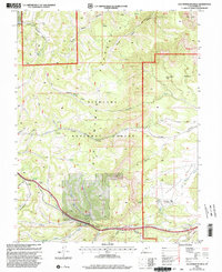
2001 Map of Old Woman Plateau
USGS Topo · Published 2003About this map
Fishlake National Forest dominates this Central Utah landscape, where the high-elevation Old Woman Plateau drops off toward the Gilson Valley. The terrain is deeply incised by a series of drainages including Jule Creek, Saleratus Creek, and Coal Mine Creek, highlighting the region's complex hydrology. Human activity is evidenced by scattered Mines and ranching outposts like Oak Spring Ranch, while Fremont Junction serves as a small crossroad at the foot of the plateau.
Find a feature on this map
51 named features on this map. Tap any name to fly to it.
Don’t see what you’re looking for? This feature index may not catch every label — zoom into the map to look around manually.
Map Details
Editions of this 2001 Old Woman Plateau Map
This is the sole edition of this map. No revisions or reprints were ever made.
Other maps of this area

1885 · Fish Lake
USGS Topo · 1:250,000

1896 · Fish Lake
USGS Topo · 1:250,000

1922 · Emery No.3
USGS Topo · 1:31,680

1925 · Acord Lakes
USGS Topo · 1:62,500

1956 · Salina
USGS Topo · 1:250,000

1960 · Salina
USGS Topo · 1:250,000

1962 · Salina
USGS Topo · 1:250,000
1966 · Water Hollow Ridge
USGS Topo · 1:24,000

1966 · Yogo Creek
USGS Topo · 1:24,000

1968 · Johns Peak
USGS Topo · 1:24,000