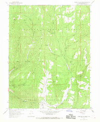
1966 Map of Water Hollow Ridge
USGS Topo · Published 1968About this map
Fishlake National Forest dominates this mid-1960s landscape, where high ridgelines and deep drainage basins define the geography of central Utah. The map detail highlights an intricate network of springs and creeks, including Wigwam Spring, Wakeup Spring, and Chokecherry Spring, which sustain the high-elevation terrain. Steep descents like Coal Falls and the carved path of Corral Canyon demonstrate the erosive force of the regional watershed.
Find a feature on this map
31 named features on this map. Tap any name to fly to it.
Don’t see what you’re looking for? This feature index may not catch every label — zoom into the map to look around manually.
Map Details
Editions of this 1966 Water Hollow Ridge Map
2 editions found
Other maps of this area

1885 · Manti
USGS Topo · 1:250,000

1885 · Fish Lake
USGS Topo · 1:250,000

1895 · Manti
USGS Topo · 1:250,000

1896 · Fish Lake
USGS Topo · 1:250,000

1922 · Wasatch
USGS Topo · 1:31,680

1925 · Acord Lakes
USGS Topo · 1:62,500

1956 · Salina
USGS Topo · 1:250,000

1956 · Price
USGS Topo · 1:250,000

1960 · Price
USGS Topo · 1:250,000

1960 · Salina
USGS Topo · 1:250,000