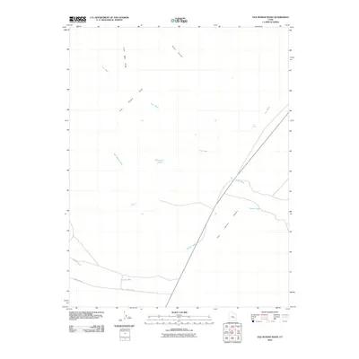
2010 Map of Old Woman Wash
USGS Topo · Published 2010About this map
The San Rafael Reef forms a dramatic geological boundary across this landscape, separating the uplifted interior from the lower San Rafael Desert. The terrain is defined by a network of drainage systems, most notably Old Woman Wash and Iron Wash, which carve through the arid environment. These ephemeral watercourses are punctuated by isolated water sources vital to the area's history, such as Mormon Tanks, Swazy Seep, and Lost Spring. The southern portion of the sheet shows the transition toward more accessible ground near the Temple Mt Rd, following the path of Temple Wash. This 2010 survey illustrates the balance between natural barriers and the thin threads of transportation that navigate the gaps in the reef, such as Ernie Canyon and Lone Man Draw.
Find a feature on this map
13 named features on this map. Tap any name to fly to it.
Don’t see what you’re looking for? This feature index may not catch every label — zoom into the map to look around manually.
Map Details
Editions of this 2010 Old Woman Wash Map
This is the sole edition of this map. No revisions or reprints were ever made.
Other maps of this area

1885 · San Rafael
USGS Topo · 1:250,000

1953 · Tidwell 2 SW
USGS Topo · 1:24,000

1953 · Tidwell 3 NW
USGS Topo · 1:24,000

1953 · Temple Mtn
USGS Topo · 1:62,500

1954 · Stinking Springs Creek 4 SW
USGS Topo · 1:24,000

1954 · Stinking Spring Creek 1 SE
USGS Topo · 1:24,000

1954 · Stinking Spring Creek 4 NE
USGS Topo · 1:24,000

1954 · Stinking Spring Creek 4 NW
USGS Topo · 1:24,000

1954 · Stinking Spring Creek 4 SE
USGS Topo · 1:24,000
1954 · Stinking Spring Creek 1 SW
USGS Topo · 1:24,000