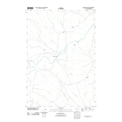
2011 Map of Oliphant Butte
USGS Topo · Published 2011About this map
The Powder River carves a winding path through this southeastern Montana landscape, anchoring a network of intermittent drainages and named coulees. At the center of the survey lies Sixmile Crossing, where the river meets a convergence of local routes, including Powderville West Rd and Powderville East Rd. The terrain is defined by prominent landmarks such as Oliphant Butte and Tepee Hill, alongside numerous erosion features like Hillside Draw and Olson Coulee. This map documents a sparsely settled ranching region where water sources like Mushroom Creek, Slaughter Creek, and Hay Creek dictate the local geography. The layout of these creeks and the crossing at the Powder River reflect the historical reliance on specific fords and drainage-aligned transit in a region dominated by physical relief rather than dense development.
Find a feature on this map
23 named features on this map. Tap any name to fly to it.
Don’t see what you’re looking for? This feature index may not catch every label — zoom into the map to look around manually.
Map Details
Editions of this 2011 Oliphant Butte Map
This is the sole edition of this map. No revisions or reprints were ever made.
Other maps of this area

1954 · Ekalaka
USGS Topo · 1:250,000

1956 · Ekalaka
USGS Topo · 1:250,000

1958 · Ekalaka
USGS Topo · 1:250,000

1965 · Ekalaka
USGS Topo · 1:250,000

1973 · Cross S School
USGS Topo · 1:24,000
1973 · Rattlesnake Hill
USGS Topo · 1:24,000

1973 · Hawkey Creek
USGS Topo · 1:24,000

1979 · Deer Creek Buttes
USGS Topo · 1:24,000

1979 · Powderville
USGS Topo · 1:24,000

1979 · Rattlesnake Ridge
USGS Topo · 1:24,000