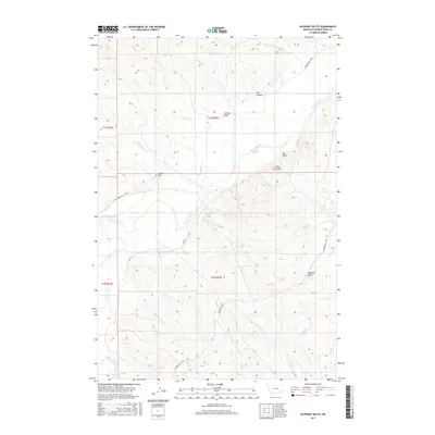
2017 Map of Oliphant Butte
USGS Topo · Published 2017About this map
Oliphant Butte and the surrounding high plains of Powder River County define this corner of Montana, where the terrain is marked by an intricate network of drainages and coulees. The Powder River carves through the landscape, joined by numerous seasonal tributaries such as Oliphant Cr, Horse Cr, and Malt Cr. This 2017 survey reveals a sparsely populated ranching country where topography dictates the flow of travel along routes like Powderville E Rd and Powderville W Rd. Local landmarks like Tepee Hill and Olson Coulee provide essential orientation in the expansive plains. The map's detailed contouring highlights the complex erosion patterns of Dry Coulee and Hillside Draw, illustrating the relationship between the prairie hydrology and the elevated buttes that characterize this remote region.
Find a feature on this map
27 named features on this map. Tap any name to fly to it.
Don’t see what you’re looking for? This feature index may not catch every label — zoom into the map to look around manually.
Map Details
Editions of this 2017 Oliphant Butte Map
This is the sole edition of this map. No revisions or reprints were ever made.
Other maps of this area
1954 · Ekalaka
USGS Topo · 1:250,000
1956 · Ekalaka
USGS Topo · 1:250,000
1958 · Ekalaka
USGS Topo · 1:250,000
1965 · Ekalaka
USGS Topo · 1:250,000
1973 · Cross S School
USGS Topo · 1:24,000
1973 · Rattlesnake Hill
USGS Topo · 1:24,000
1973 · Hawkey Creek
USGS Topo · 1:24,000
1979 · Deer Creek Buttes
USGS Topo · 1:24,000
1979 · Powderville
USGS Topo · 1:24,000
1979 · Rattlesnake Ridge
USGS Topo · 1:24,000