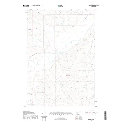
2020 Map of Oliphant Butte
USGS Topo · Published 2020About this map
The Powder River carves a winding path through this corner of Powder River County, Montana, defining a landscape of complex drainage systems and isolated high points. Near the eastern edge, Oliphant Butte rises above the surrounding terrain, served by the local network of Powderville East Rd. The hydrology of the area is remarkably dense, with named drainages like Mushroom Cr, Prairie Cr, and Oliphant Cr branching away from the main river valley. Cultural features are sparse in this rural expanse, though landmarks such as Tepee Hill and Hillside Draw provide essential points of orientation for those navigating the backcountry. This 2020 map documents the modern layout of secondary roads, including W Powderville Rd, as they navigate the ridges and coulees that characterize the northern Great Plains environment.
Find a feature on this map
26 named features on this map. Tap any name to fly to it.
Don’t see what you’re looking for? This feature index may not catch every label — zoom into the map to look around manually.
Map Details
Editions of this 2020 Oliphant Butte Map
This is the sole edition of this map. No revisions or reprints were ever made.
Other maps of this area

1954 · Ekalaka
USGS Topo · 1:250,000

1956 · Ekalaka
USGS Topo · 1:250,000

1958 · Ekalaka
USGS Topo · 1:250,000

1965 · Ekalaka
USGS Topo · 1:250,000

1973 · Cross S School
USGS Topo · 1:24,000
1973 · Rattlesnake Hill
USGS Topo · 1:24,000

1973 · Hawkey Creek
USGS Topo · 1:24,000

1979 · Deer Creek Buttes
USGS Topo · 1:24,000

1979 · Powderville
USGS Topo · 1:24,000

1979 · Rattlesnake Ridge
USGS Topo · 1:24,000