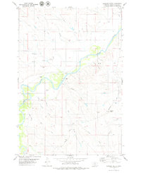
1979 Map of Oliphant Butte
USGS Topo · Published 1979About this map
Powder River meanders through this portion of Powder River County, Montana, carving a wide valley floor marked by seasonal crossings and local landmarks. The landscape in the late 1970s is characterized by its agricultural and transit features, including the Jurica School and several Landing Strips situated near the riverbanks. The Powderville Road serves as the primary artery through this territory, connecting remote sites like Sixmile Crossing and the prominent Oliphant Butte. Numerous intermittent watercourses, such as Rough Creek and Slaughter Cherry Creek, drain into the main river valley from the surrounding breaks and ridges. This map documents a period when local navigation relied on specific points like the Ford and specialized landmarks like the Flowing Well, illustrating the practical geography of rural Montana ranching and transit before the turn of the century.
Find a feature on this map
27 named features on this map. Tap any name to fly to it.
Don’t see what you’re looking for? This feature index may not catch every label — zoom into the map to look around manually.
Map Details
Editions of this 1979 Oliphant Butte Map
This is the sole edition of this map. No revisions or reprints were ever made.
Other maps of this area

1954 · Ekalaka
USGS Topo · 1:250,000

1956 · Ekalaka
USGS Topo · 1:250,000

1958 · Ekalaka
USGS Topo · 1:250,000

1965 · Ekalaka
USGS Topo · 1:250,000

1973 · Cross S School
USGS Topo · 1:24,000
1973 · Rattlesnake Hill
USGS Topo · 1:24,000

1973 · Hawkey Creek
USGS Topo · 1:24,000

1979 · Deer Creek Buttes
USGS Topo · 1:24,000

1979 · Powderville
USGS Topo · 1:24,000

1979 · Rattlesnake Ridge
USGS Topo · 1:24,000