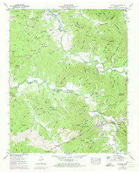
1949 Map of Olivehill
USGS Topo · Published 1973About this map
Hardin Creek winds through the heart of this Hardin County landscape, feeding into the expansive Kentucky Lake at the northern edge. The settlement of Olivehill serves as a primary hub in the south, positioned near the Arch Bridge and Hardin Spring. The area's social and historical fabric is visible through a high concentration of family and community landmarks, including Mt Carmel Ch, Bethlehem Cem, and Union Chapel.
Find a feature on this map
162 named features on this map. Tap any name to fly to it.
Don’t see what you’re looking for? This feature index may not catch every label — zoom into the map to look around manually.
Map Details
Editions of this 1949 Olivehill Map
3 editions found
Other maps of this area

1905 · Waynesboro
USGS Topo · 1:125,000

1936 · Savannah
USGS Topo · 1:24,000

1936 · Wolf Pit Ridge
USGS Topo · 1:24,000

1936 · Hookers Bend
USGS Topo · 1:24,000

1936 · Eagle Creek
USGS Topo · 1:24,000

1936 · Thurman
USGS Topo · 1:24,000

1936 · Olivehill
USGS Topo · 1:24,000

1936 · Bath Springs
USGS Topo · 1:24,000

1936 · Clifton
USGS Topo · 1:24,000

1936 · Martins Mills
USGS Topo · 1:24,000