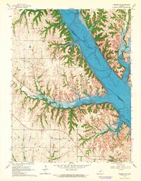
1964 Map of Olsburg SW
USGS Topo · Published 1965About this map
Tuttle Creek Reservoir dominates the landscape north of Manhattan, Kansas, reflecting a mid-century period of massive hydraulic engineering and land transformation along the Big Blue River. This survey captures the region just after the reservoir's creation, illustrating the inundation zones and the emergence of new lakeside infrastructure like the Stockdale Recreation Area and Garrison Recreation Area. On the western shore, the small community of Sedalia persists near the Sedalia Ch, while the surrounding terrain is marked by a mix of upland farming and drainage features such as Kitten Creek and Baldwin Creek. Genealogists will find critical landmarks preserved in the record, including the Hebron Cem and Carnahan-Garrison Cem, which sit amidst a grid of section lines and isolated features like a Landing Strip and a Quarry.
Find a feature on this map
25 named features on this map. Tap any name to fly to it.
Don’t see what you’re looking for? This feature index may not catch every label — zoom into the map to look around manually.
Map Details
Editions of this 1964 Olsburg SW Map
3 editions found
Other maps of this area

1886 · Junction City
USGS Topo · 1:125,000

1889 · Junction City
USGS Topo · 1:125,000

1894 · Junction City
USGS Topo · 1:125,000

1947 · Manhattan
USGS Topo · 1:62,500

1947 · Fort Riley
USGS Topo · 1:62,500

1950 · Keats
USGS Topo · 1:24,000

1950 · Manhattan
USGS Topo · 1:24,000

1951 · Wind Creek
USGS Topo · 1:24,000

1955 · Fort Riley NE
USGS Topo · 1:24,000
1955 · Manhattan
USGS Topo · 1:24,000