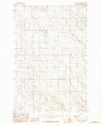
1983 Map of Olson Coulee North
USGS Topo · Published 1983About this map
The rolling plains and drainage systems of Dawson County define this 1983 topographic study, revealing a landscape dominated by seasonal waterways and rugged coulees. A notable site of local interest is the small Cem located in the western portion of the map, providing a potential focal point for genealogists researching rural family burials in this corner of Montana. The map is primarily characterized by the winding paths of Corral Creek and its many tributaries, alongside Brush Coulee and Bluff Creek to the northeast.
Find a feature on this map
7 named features on this map. Tap any name to fly to it.
Don’t see what you’re looking for? This feature index may not catch every label — zoom into the map to look around manually.
Map Details
Editions of this 1983 Olson Coulee North Map
This is the sole edition of this map. No revisions or reprints were ever made.
Other maps of this area

1954 · Glendive
USGS Topo · 1:250,000

1957 · Glendive
USGS Topo · 1:250,000

1958 · Glendive
USGS Topo · 1:250,000

1982 · Circle
USGS Topo · 1:100,000

1983 · Johnson Reservoir NW
USGS Topo · 1:24,000

1983 · Woodworth Hill
USGS Topo · 1:24,000

1983 · Olson Coulee South
USGS Topo · 1:24,000

1983 · Mount Antelope
USGS Topo · 1:24,000

1983 · Deer Creek Church
USGS Topo · 1:24,000

1983 · Circle Reservoir
USGS Topo · 1:24,000