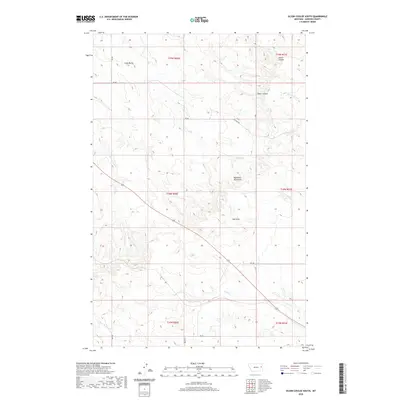
2020 Map of Olson Coulee South
USGS Topo · Published 2020About this map
Big Sheep Mountains dominate the central landscape of this Dawson County region, serving as a prominent landmark for the network of drainage coulees and creeks that define the local topography. This 2020 survey illustrates a sparsely settled area where life is organized around the rugged relief of Crazy Butte and the watershed of Sioux Cr. The map details a complex system of local access routes like RD 401 and the Pasture Trl, which navigate between the high ridges and the water-carved valleys of Olson Coulee and Stilson Coulee. The presence of numerous seasonal watercourses, including Spring Cr and Hay Cr, highlights the importance of drainage patterns in this semi-arid terrain, while High Point provides a clear tactical reference for the surrounding sections of the Public Land Survey System.
Find a feature on this map
25 named features on this map. Tap any name to fly to it.
Don’t see what you’re looking for? This feature index may not catch every label — zoom into the map to look around manually.
Map Details
Editions of this 2020 Olson Coulee South Map
This is the sole edition of this map. No revisions or reprints were ever made.
Other maps of this area

1954 · Glendive
USGS Topo · 1:250,000

1957 · Glendive
USGS Topo · 1:250,000

1958 · Glendive
USGS Topo · 1:250,000

1982 · Circle
USGS Topo · 1:100,000

1983 · Johnson Reservoir NW
USGS Topo · 1:24,000
1983 · Union School
USGS Topo · 1:24,000

1983 · Woodworth Hill
USGS Topo · 1:24,000

1983 · Olson Coulee South
USGS Topo · 1:24,000

1983 · Mount Antelope
USGS Topo · 1:24,000

1983 · Deer Creek Church
USGS Topo · 1:24,000