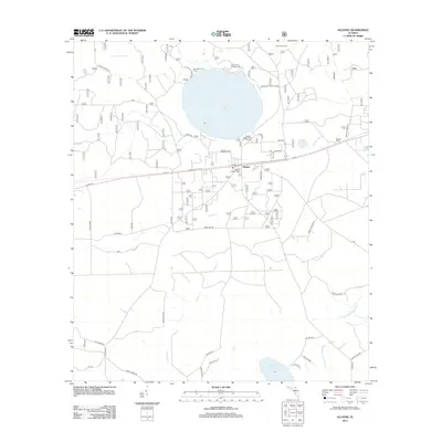
2012 Map of Olustee
USGS Topo · Published 2012About this map
Ocean Pond dominates the northern landscape of this Baker County territory, serving as a focal point for recreation and forest management. The area is characterized by low-lying wetlands such as Little Gum Swamp and the headwaters of the S Prong Saint Marys River, which wind through the timberlands. The settlement of Olustee sits at a critical transportation junction where Us-90 runs parallel to the railroad, reflecting the traditional corridor of commerce and travel in North Florida.
Find a feature on this map
39 named features on this map. Tap any name to fly to it.
Don’t see what you’re looking for? This feature index may not catch every label — zoom into the map to look around manually.
Map Details
Editions of this 2012 Olustee Map
This is the sole edition of this map. No revisions or reprints were ever made.
Other maps of this area

1954 · Valdosta
USGS Topo · 1:250,000

1958 · Valdosta
USGS Topo · 1:250,000

1959 · Valdosta
USGS Topo · 1:250,000

1961 · Deep Creek
USGS Topo · 1:24,000

1962 · Lake City East
USGS Topo · 1:24,000

1963 · Olustee
USGS Topo · 1:24,000

1963 · Sanderson South
USGS Topo · 1:24,000

1963 · Ellisville
USGS Topo · 1:24,000

1966 · Lake Butler
USGS Topo · 1:24,000
1966 · Lulu
USGS Topo · 1:24,000