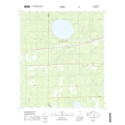
2018 Map of Olustee
USGS Topo · Published 2018About this map
Ocean Pond dominates the northern landscape of this Baker County quadrangle, situated within the expansive Osceola National Forest. The settlement of Olustee sits south of the water, a historic focal point where local geography meets the long-distance path of the Florida National Scenic Trail. This terrain is defined by a high concentration of wetlands and water bodies, including Little Gum Swamp and Palestine Lake, which dictate the local drainage patterns toward Olustee Cr. For those researching local heritage, the map identifies Dyess Cem and Monument Cem, providing precise locations for these small rural burial grounds. The road network, including Mount Carrie Rd and Seventeen Mile Camp Rd, reveals the infrastructure used to manage the vast timberlands and recreation areas of the national forest during the early 21st century.
Find a feature on this map
46 named features on this map. Tap any name to fly to it.
Don’t see what you’re looking for? This feature index may not catch every label — zoom into the map to look around manually.
Map Details
Editions of this 2018 Olustee Map
This is the sole edition of this map. No revisions or reprints were ever made.
Other maps of this area

1954 · Valdosta
USGS Topo · 1:250,000

1958 · Valdosta
USGS Topo · 1:250,000

1959 · Valdosta
USGS Topo · 1:250,000

1961 · Deep Creek
USGS Topo · 1:24,000

1962 · Lake City East
USGS Topo · 1:24,000

1963 · Olustee
USGS Topo · 1:24,000

1963 · Sanderson South
USGS Topo · 1:24,000

1963 · Ellisville
USGS Topo · 1:24,000

1966 · Lake Butler
USGS Topo · 1:24,000
1966 · Lulu
USGS Topo · 1:24,000