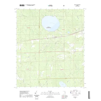
2021 Map of Olustee
USGS Topo · Published 2021About this map
Osceola National Forest dominates this part of Baker and Columbia counties, a landscape defined by the shallow waters of Ocean Pond and the headwaters of the South Prong Saint Marys River. The small settlement of Olustee sits at a critical junction of local history, serving as the gateway to the site of Florida's largest Civil War engagement. This modern survey detail shows the preserved grounds of the Olustee Battlefield Trl and the nearby Monument Cem, marking where the landscape's natural features influenced tactical movements. The surrounding terrain is characterized by low-lying wetlands like Little Gum Swamp and Holder Bay, with drainage provided by the winding Olustee Creek. Further south, the map captures the transition into Union County near Palestine Lake, illustrating a rural landscape where forest service roads and established trails like the Florida National Scenic Trl provide the primary access through the dense pine flatwoods.
Find a feature on this map
48 named features on this map. Tap any name to fly to it.
Don’t see what you’re looking for? This feature index may not catch every label — zoom into the map to look around manually.
Map Details
Editions of this 2021 Olustee Map
This is the sole edition of this map. No revisions or reprints were ever made.
Other maps of this area

1954 · Valdosta
USGS Topo · 1:250,000

1958 · Valdosta
USGS Topo · 1:250,000

1959 · Valdosta
USGS Topo · 1:250,000

1961 · Deep Creek
USGS Topo · 1:24,000

1962 · Lake City East
USGS Topo · 1:24,000

1963 · Olustee
USGS Topo · 1:24,000

1963 · Sanderson South
USGS Topo · 1:24,000

1963 · Ellisville
USGS Topo · 1:24,000

1966 · Lake Butler
USGS Topo · 1:24,000
1966 · Lulu
USGS Topo · 1:24,000