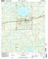
2005 Map of Olustee
USGS Topo · Published 2006About this map
Olustee Battlefield Hist Site stands as a significant landmark in the northeast, marking the location of Florida's largest Civil War engagement within the broader expanse of the Osceola National Forest. This 2005 revision shows a landscape dominated by the managed pine flatwoods and cypress heads of the Olustee Experimental Forest and the vast Ocean Pond. The small community of Olustee serves as the primary hub, situated near several historic burial grounds including Dyess Cem and Monument Cem. To the south, the terrain transitions into a complex of wetlands and water bodies such as South Prong Swamp and Palestine Lake, highlighting the hydrologic connectivity of the region before it reaches the Baker and Union County line. The presence of the Osceola Ranger District and Hog Pen Landing Hunt Camp underscores the area's continued use for federal land management and seasonal recreation.
Find a feature on this map
18 named features on this map. Tap any name to fly to it.
Don’t see what you’re looking for? This feature index may not catch every label — zoom into the map to look around manually.
Map Details
Editions of this 2005 Olustee Map
This is the sole edition of this map. No revisions or reprints were ever made.
Other maps of this area

1954 · Valdosta
USGS Topo · 1:250,000

1958 · Valdosta
USGS Topo · 1:250,000

1959 · Valdosta
USGS Topo · 1:250,000

1961 · Deep Creek
USGS Topo · 1:24,000

1962 · Lake City East
USGS Topo · 1:24,000

1963 · Olustee
USGS Topo · 1:24,000

1963 · Sanderson South
USGS Topo · 1:24,000

1963 · Ellisville
USGS Topo · 1:24,000

1966 · Lake Butler
USGS Topo · 1:24,000
1966 · Lulu
USGS Topo · 1:24,000