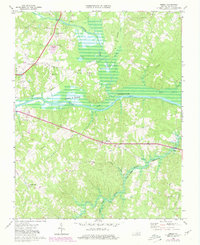
1968 Map of Omega
USGS Topo · Published 1980About this map
The Banister River and Dan River converge within the John H Kerr Reservoir in this landscape of Halifax County, Virginia. The 1968 survey, revised in 1980, shows a transition from traditional agricultural settlements to modern infrastructure. Communities like Omega and Wolf Trap are joined by the Southern railroad line, while evidence of 20th-century development is found at the South Boston Speedway and the William M Tuck Airport. The river valleys are marked by numerous small churches that served these rural populations, including Ebenezer Ch, Revelation Ch, and Mt Cana Ch. To the south, the Hyco River feeds into the reservoir near Moffett, reflecting a region where water management and transportation corridors have long shaped the local economy. Genealogists will find a high density of small family or community cemeteries and isolated houses throughout the hills surrounding Hilly Creek.
Find a feature on this map
39 named features on this map. Tap any name to fly to it.
Don’t see what you’re looking for? This feature index may not catch every label — zoom into the map to look around manually.
Map Details
Editions of this 1968 Omega Map
3 editions found
Other maps of this area

1941 · Clarksville
USGS Topo · 1:48,000

1943 · Clarksville
USGS Topo · 1:62,500

1953 · South Boston
USGS Topo · 1:62,500

1953 · Greensboro
USGS Topo · 1:250,000

1954 · Greensboro
USGS Topo · 1:250,000

1954 · Clover
USGS Topo · 1:62,500

1954 · Halifax
USGS Topo · 1:62,500

1957 · South Boston
USGS Topo · 1:62,500

1957 · Clarksville
USGS Topo · 1:62,500

1962 · Greensboro
USGS Topo · 1:250,000