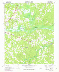
1968 Map of Omega
USGS Topo · Published 1975About this map
The Banister River and Hyco River converge into the broad expanse of the John H Kerr Reservoir in this Halifax County landscape. Small rural communities like Wolf Trap and Omega are centers of local life, characterized by a high density of country churches such as Ebenezer Ch, Grace Ch, and Mt Cana Ch. The presence of the William M Tuck Airport and South Boston Speedway near Five Forks indicates a transition toward modern regional infrastructure and recreation, while the Southern railroad line maintains the traditional transport corridor through the northern woods. Further south, the terrain becomes more localized around settlements like Centerville and Moffett, where family-named landmarks like Jeter Chapel and the White Oak Fork Ch provide essential clues for genealogists and local historians tracing the social fabric of the late 1960s.
Find a feature on this map
37 named features on this map. Tap any name to fly to it.
Don’t see what you’re looking for? This feature index may not catch every label — zoom into the map to look around manually.
Map Details
Editions of this 1968 Omega Map
3 editions found
Other maps of this area

1941 · Clarksville
USGS Topo · 1:48,000

1943 · Clarksville
USGS Topo · 1:62,500

1953 · South Boston
USGS Topo · 1:62,500

1953 · Greensboro
USGS Topo · 1:250,000

1954 · Greensboro
USGS Topo · 1:250,000

1954 · Clover
USGS Topo · 1:62,500

1954 · Halifax
USGS Topo · 1:62,500

1957 · South Boston
USGS Topo · 1:62,500

1957 · Clarksville
USGS Topo · 1:62,500

1962 · Greensboro
USGS Topo · 1:250,000