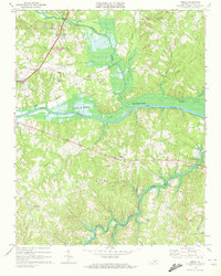
1968 Map of Omega
USGS Topo · Published 1972About this map
Banister River and the Dan River converge in this section of Halifax County, where the John H Kerr Reservoir begins its reach across the landscape. The topography is defined by the numerous creeks and branches, such as Grassy Creek and Little Hyco River, that carve through the Hilly terrain. Transportation and recreation hubs are clustered in the western portion of the map, including the William M Tuck Airport and the South Boston Speedway. Small communities and crossroad settlements like Wolf Trap, Omega, and Five Forks are linked by the Southern railroad line and local roads. Several historic congregations are mapped here, from Revelation Ch near the river to Mt Cana Ch and Tyler Chapel, providing a clear look at the rural social geography of the late 1960s before modern developments altered these traditional centers.
Find a feature on this map
34 named features on this map. Tap any name to fly to it.
Don’t see what you’re looking for? This feature index may not catch every label — zoom into the map to look around manually.
Map Details
Editions of this 1968 Omega Map
3 editions found
Other maps of this area

1941 · Clarksville
USGS Topo · 1:48,000

1943 · Clarksville
USGS Topo · 1:62,500

1953 · South Boston
USGS Topo · 1:62,500

1953 · Greensboro
USGS Topo · 1:250,000

1954 · Greensboro
USGS Topo · 1:250,000

1954 · Clover
USGS Topo · 1:62,500

1954 · Halifax
USGS Topo · 1:62,500

1957 · South Boston
USGS Topo · 1:62,500

1957 · Clarksville
USGS Topo · 1:62,500

1962 · Greensboro
USGS Topo · 1:250,000