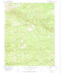
1952 Map of Omo Ranch
USGS Topo · Published 1974About this map
Coles Station stands as a focal point in this remote stretch of the Sierra Nevada foothills, representing the established outposts that once served travelers and settlers in the high country of El Dorado County. The landscape is defined by the steep, winding drainages and ridges characteristic of the western slopes of the mountains, where early transit routes followed the natural contours of the land. This 1952 field-checked survey preserves the localized nomenclature of the mid-twentieth century, capturing the area's transition from an era of pioneer waystations to modern forest management and recreation. The placement of Coles Station relative to the surrounding topography illustrates the critical role these stations played in providing water, rest, and supplies for those navigating the rugged ascent toward the crest.
Find a feature on this map
1 named feature on this map. Tap any name to fly to it.
Don’t see what you’re looking for? This feature index may not catch every label — zoom into the map to look around manually.
Map Details
Editions of this 1952 Omo Ranch Map
5 editions found


Other maps of this area

1889 · Jackson
USGS Topo · 1:125,000

1889 · Pyramid Peak
USGS Topo · 1:125,000

1891 · Big Trees
USGS Topo · 1:125,000

1891 · Placerville
USGS Topo · 1:125,000

1891 · Pyramid Peak
USGS Topo · 1:125,000

1892 · Jackson
USGS Topo · 1:125,000

1892 · Placerville
USGS Topo · 1:125,000

1893 · Placerville
USGS Topo · 1:125,000

1894 · Big Trees
USGS Topo · 1:125,000

1895 · Pyramid Peak
USGS Topo · 1:125,000