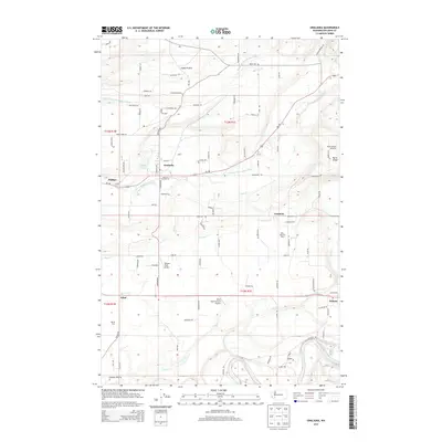
2013 Map of Onalaska
USGS Topo · Published 2013About this map
The agricultural and aviation landscape of Lewis County unfolds along the Middle Fork Newaukum River and S Fork Newaukum River. The settlement of Onalaska serves as a central hub, flanked by the waters of Carlisle Lake and several specialized dairy operations, including Lacamas Dairy, Misty Morning Dairy, and Alpine Dairy. This 2013 survey illustrates a high density of small-scale aviation infrastructure, with Nelsons Nitch Airport, Burnt Ridge Airstrip, and the humorously named Ethel International Airport distributed across the prairie and ridge. Local history is anchored by the Alpha Cem in the north near Alpha Prairie, while the southern reaches of the map transition toward Cowlitz Prairie and the Cowlitz River. The road network connects established communities like Ethel, Salkum, and Lacamas, tracing the legacy of rural development in the region.
Find a feature on this map
103 named features on this map. Tap any name to fly to it.
Don’t see what you’re looking for? This feature index may not catch every label — zoom into the map to look around manually.
Map Details
Editions of this 2013 Onalaska Map
This is the sole edition of this map. No revisions or reprints were ever made.
Other maps of this area

1916 · Chehalis
USGS Topo · 1:125,000

1941 · Olequa
USGS Topo · 1:62,500

1942 · Toutle
USGS Topo · 1:62,500

1943 · Willapa
USGS Topo · 1:62,500

1953 · Hoquiam
USGS Topo · 1:250,000

1953 · Toutle
USGS Topo · 1:62,500

1953 · Castle Rock
USGS Topo · 1:62,500

1954 · Onalaska
USGS Topo · 1:62,500

1954 · Centralia
USGS Topo · 1:62,500

1957 · Hoquiam
USGS Topo · 1:250,000