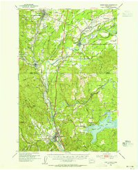
1953 Map of Castle Rock
USGS Topo · Published 1955About this map
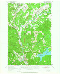
Winlock and Toledo anchor this 1953 mapping of the Cowlitz River valley, a landscape defined by its fertile flats and transitioning timberlands. The river itself meanders through Smokey Valley and past Barnes State Park, flanked by the massive infrastructure of the Northern Pacific Railroad and the Pacific Highway. The sheet captures a moment of institutional change, documenting numerous defunct educational sites like the Layton Prairie Sch (Aban'd) and Brim Creek Sch (Aban'd), while the active St Marys Academy remains a prominent landmark near Toledo. To the south, the terrain shifts as the Toutle River joins the Cowlitz near Castle Rock. Further east, the sprawling waters of Silver Lake are detailed with islands such as Dixon Island and Goat Island, illustrating the complex water and rail network that supported the local logging and agricultural economy of the early 1950s.
Find a feature on this map
58 named features on this map. Tap any name to fly to it.
Don’t see what you’re looking for? This feature index may not catch every label — zoom into the map to look around manually.
Map Details
Editions of this 1953 Castle Rock Map
2 editions found
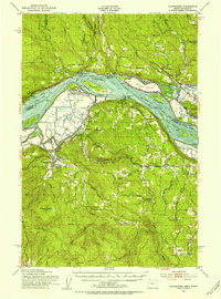
Other maps of this area

1916 · Chehalis
USGS Topo · 1:125,000

1919 · Mayger
USGS Topo · 1:62,500

1921 · Kalama
USGS Topo · 1:62,500

1941 · Meskill
USGS Topo · 1:62,500

1941 · Olequa
USGS Topo · 1:62,500

1941 · Clatskanie
USGS Topo · 1:62,500

1942 · Toutle
USGS Topo · 1:62,500

1943 · Willapa
USGS Topo · 1:62,500

1943 · Pigeon Springs
USGS Topo · 1:62,500
1952 · Clatskanie
USGS Topo · 1:62,500