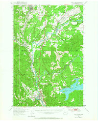
1953 Map of Castle Rock
USGS Topo · Published 1965About this map
The Cowlitz River winds through this mid-century landscape, serving as a primary corridor for the communities of Toledo, Vader, and Castle Rock. The map illustrates a region transitioning from rural homesteads to a more modern infrastructure, evidenced by the presence of the Toledo-Winlock Airport and the Pacific Highway. Notable for genealogists, several local schools are marked as abandoned by 1953, including the Upper Cowlitz Sch and Layton Prairie Sch, reflecting shifts in local education and settlement patterns.
Find a feature on this map
72 named features on this map. Tap any name to fly to it.
Don’t see what you’re looking for? This feature index may not catch every label — zoom into the map to look around manually.
Map Details
Editions of this 1953 Castle Rock Map
2 editions found
Other maps of this area

1916 · Chehalis
USGS Topo · 1:125,000

1919 · Mayger
USGS Topo · 1:62,500

1921 · Kalama
USGS Topo · 1:62,500

1941 · Meskill
USGS Topo · 1:62,500

1941 · Olequa
USGS Topo · 1:62,500

1941 · Clatskanie
USGS Topo · 1:62,500

1942 · Toutle
USGS Topo · 1:62,500

1943 · Willapa
USGS Topo · 1:62,500

1943 · Pigeon Springs
USGS Topo · 1:62,500
1952 · Clatskanie
USGS Topo · 1:62,500