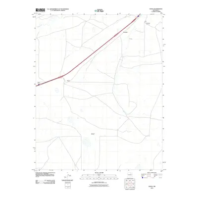
2010 Map of Onava
USGS Topo · Published 2010About this map
Sapello River meanders across the northwestern corner of this high-plains landscape, where the open terrain is defined by ranching operations and isolated water sources. Small settlements and named ranch sites like Kroenigs and the Holt Brothers Circle Ranch anchor the local geography during the early twenty-first century. The map illustrates a transition from the riparian environment of the river to the drier tablelands punctuated by necessary infrastructure such as Walker Windmill and Shoemaker Windmill. Transport and access are facilitated by a major transportation corridor and local routes including Onava Rd, which connects the small community of Onava to the surrounding territory. This survey reflects the enduring cattle-ranching heritage of San Miguel County, showing how family-named landmarks like Circle Ranch continue to define land use in this part of New Mexico.
Find a feature on this map
8 named features on this map. Tap any name to fly to it.
Don’t see what you’re looking for? This feature index may not catch every label — zoom into the map to look around manually.
Map Details
Editions of this 2010 Onava Map
This is the sole edition of this map. No revisions or reprints were ever made.
Other maps of this area

1889 · Las Vegas
USGS Topo · 1:125,000

1891 · Las Vegas
USGS Topo · 1:125,000

1892 · Watrous
USGS Topo · 1:125,000

1893 · Las Vegas
USGS Topo · 1:125,000

1894 · Watrous
USGS Topo · 1:125,000

1954 · Santa Fe
USGS Topo · 1:250,000

1958 · Santa Fe
USGS Topo · 1:250,000

1963 · Lake Isabel
USGS Topo · 1:24,000
1963 · Las Vegas SE
USGS Topo · 1:24,000
1963 · Las Vegas
USGS Topo · 1:24,000