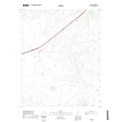
2023 Map of Onava
USGS Topo · Published 2023About this map
Onava and Kroenigs serve as the primary landmarks in this high-desert portion of San Miguel County. The landscape is defined by the winding course of the Sapello River in the northwest corner, which carves through the undulating terrain. Modern transportation corridors dominate the local geography, with the Interstate 25 corridor bisecting the region. This thoroughfare is supported by a network of access points, including Onava Frontage Rd, Kroenigs Frontage Rd, and W Frontage Rd. The map illustrates how traditional settlements have adapted to modern infrastructure, where established place names now anchor the intersections of regional transit. While the terrain is marked by numerous ephemeral water features and complex contouring, the presence of these named settlements highlights the enduring human footprint in this part of New Mexico.
Find a feature on this map
6 named features on this map. Tap any name to fly to it.
Don’t see what you’re looking for? This feature index may not catch every label — zoom into the map to look around manually.
Map Details
Editions of this 2023 Onava Map
This is the sole edition of this map. No revisions or reprints were ever made.
Other maps of this area

1889 · Las Vegas
USGS Topo · 1:125,000

1891 · Las Vegas
USGS Topo · 1:125,000

1892 · Watrous
USGS Topo · 1:125,000

1893 · Las Vegas
USGS Topo · 1:125,000

1894 · Watrous
USGS Topo · 1:125,000

1954 · Santa Fe
USGS Topo · 1:250,000

1958 · Santa Fe
USGS Topo · 1:250,000

1963 · Lake Isabel
USGS Topo · 1:24,000
1963 · Las Vegas SE
USGS Topo · 1:24,000
1963 · Las Vegas
USGS Topo · 1:24,000