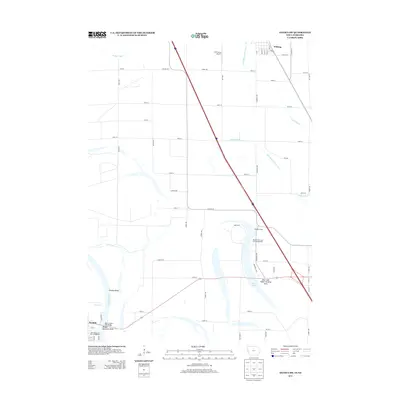
2013 Map of Onawa SW
USGS Topo · Published 2013About this map
The Missouri River defines the western edge of this landscape, winding through Tieville Bend and Decature Bend where the border between Iowa and Nebraska is shaped by the river's historic path. The settlement of Decatur sits just across the water, connected to the Monona County side via the Burt County Toll Bridge. This area is characterized by a complex network of agricultural drainage, featuring the McCandless Cleghorn Ditch, Murphy Ditch, and Myrland Ditch, which manage the low-lying plains around Whiting.
Find a feature on this map
45 named features on this map. Tap any name to fly to it.
Don’t see what you’re looking for? This feature index may not catch every label — zoom into the map to look around manually.
Map Details
Editions of this 2013 Onawa SW Map
This is the sole edition of this map. No revisions or reprints were ever made.
Other maps of this area

1955 · Sioux City
USGS Topo · 1:250,000

1955 · Fremont
USGS Topo · 1:250,000

1957 · Fremont
USGS Topo · 1:250,000

1958 · Sioux City
USGS Topo · 1:250,000

1958 · Fremont
USGS Topo · 1:250,000

1959 · Sioux City
USGS Topo · 1:250,000

1966 · Macy
USGS Topo · 1:24,000

1969 · Onawa
USGS Topo · 1:24,000

1969 · Albaton
USGS Topo · 1:24,000
1969 · Hornick
USGS Topo · 1:24,000