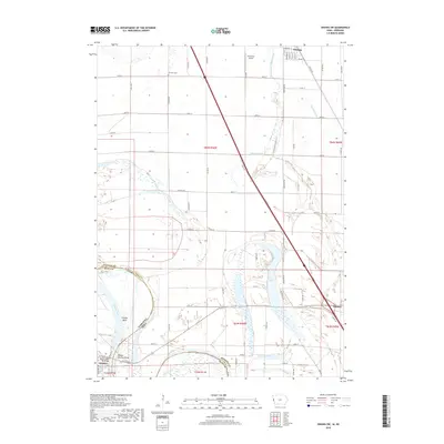
2018 Map of Onawa SW
USGS Topo · Published 2018About this map
Blue Lake sits at the center of this Missouri River landscape, marking the relic of a former river channel in Monona County. The river itself, defining the boundary between Nebraska and Iowa, carves dramatic curves at Tieville Bend and Middle Decatur Bend, illustrating the shifting hydrology of the floodplain. A complex network of drainage infrastructure, including the McCandless-Cleghorn Ditch, Myrland Ditch, and Murphy Ditch, crisscrosses the low-lying agricultural fields to manage the water levels of this fertile bottomland. To the north, the town of Whiting is clearly gridded with streets like Walnut St and Bertram St, while the edge of Onawa appears in the southeast. Genealogists and local historians will find the Harrison Cem positioned among the rural section lines, while the B-8 Farms Airport reflects the integration of aviation into modern industrial farming.
Find a feature on this map
59 named features on this map. Tap any name to fly to it.
Don’t see what you’re looking for? This feature index may not catch every label — zoom into the map to look around manually.
Map Details
Editions of this 2018 Onawa SW Map
This is the sole edition of this map. No revisions or reprints were ever made.
Other maps of this area

1955 · Sioux City
USGS Topo · 1:250,000

1955 · Fremont
USGS Topo · 1:250,000

1957 · Fremont
USGS Topo · 1:250,000

1958 · Sioux City
USGS Topo · 1:250,000

1958 · Fremont
USGS Topo · 1:250,000

1959 · Sioux City
USGS Topo · 1:250,000

1966 · Macy
USGS Topo · 1:24,000

1969 · Onawa
USGS Topo · 1:24,000

1969 · Albaton
USGS Topo · 1:24,000
1969 · Hornick
USGS Topo · 1:24,000