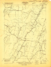
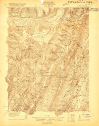
1921 Map of Onego
USGS Topo · Published 1921About this map
The Allegheny Front forms the dramatic backbone of this 1921 landscape, where the high-altitude Flat Rock Plains and Ruhrbaugh Plains drop toward the river valleys of the North Fork South Branch Potomac River. Within the borders of the Monongahela National Forest, a high density of small-scale mountain institutions serves the scattered agrarian communities of Onego, Macksville, and Upper Tract.
Find a feature on this map
126 named features on this map. Tap any name to fly to it.
Don’t see what you’re looking for? This feature index may not catch every label — zoom into the map to look around manually.
Map Details
Editions of this 1921 Onego Map
2 editions found
Other maps of this area

1886 · St. George
USGS Topo · 1:125,000

1889 · Beverly
USGS Topo · 1:125,000

1891 · St. George
USGS Topo · 1:125,000

1892 · Beverly
USGS Topo · 1:125,000

1892 · Franklin
USGS Topo · 1:125,000

1895 · Piedmont
USGS Topo · 1:125,000

1896 · Franklin
USGS Topo · 1:125,000

1908 · Parsons
USGS Topo · 1:62,500

1916 · Davis
USGS Topo · 1:48,000

1918 · Davis
USGS Topo · 1:62,500