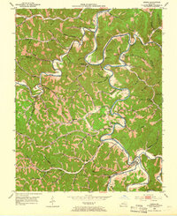
1953 Map of Oneida
USGS Topo · Published 1966About this map
The confluence of Red Bird River and Goose Creek forms the South Fork Kentucky River at Oneida, anchoring this detailed mid-century survey of the Owsley and Clay county line. The landscape is defined by its extensive network of hollows and ridges, where small mountain settlements like Teges, Ammie, and Felty appear as clusters of homes and family-named schools. The presence of the Oneida Lookout Tower and numerous gas wells across the southern ridges suggests the early industrial footprint of natural resource extraction within the predominantly agrarian creek bottoms.
Find a feature on this map
96 named features on this map. Tap any name to fly to it.
Don’t see what you’re looking for? This feature index may not catch every label — zoom into the map to look around manually.
Map Details
Editions of this 1953 Oneida Map
2 editions found
Other maps of this area

1891 · Manchester
USGS Topo · 1:125,000

1952 · Manchester
USGS Topo · 1:24,000

1953 · Oneida
USGS Topo · 1:24,000

1953 · Cowcreek
USGS Topo · 1:24,000

1953 · Big Creek
USGS Topo · 1:24,000

1953 · Mistletoe
USGS Topo · 1:24,000

1953 · Booneville
USGS Topo · 1:24,000

1953 · Sturgeon
USGS Topo · 1:24,000

1954 · Barcreek
USGS Topo · 1:24,000

1954 · Maulden
USGS Topo · 1:24,000