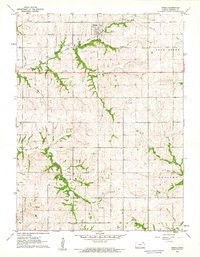
1961 Map of Oneida
USGS Topo · Published 1962About this map
Oneida serves as the primary hub of this rural landscape, situated at the junction of the Union Pacific railroad and the headwaters of Harris Creek. The township divisions of Gilman, Rock Creek, Adams, and Capioma define the political geography, reflecting a period when small-scale agriculture dominated the Nemaha County terrain. Waterways such as Tennessee Creek and Muddy Creek carve through the land, shaping the local topography and placement of rural homesteads. Genealogists can identify the Ford Cem in the western portion of the quadrangle, while industrial history is represented by a lone Gravel Pit near Wolfley Creek. The map documents a classic Midwestern rail-and-creek economy, capturing the spatial relationship between the town and the surrounding townships just before significant changes in modern agricultural consolidation.
Find a feature on this map
12 named features on this map. Tap any name to fly to it.
Don’t see what you’re looking for? This feature index may not catch every label — zoom into the map to look around manually.
Map Details
Editions of this 1961 Oneida Map
This is the sole edition of this map. No revisions or reprints were ever made.
Other maps of this area

1888 · Hiawatha
USGS Topo · 1:125,000

1889 · Seneca
USGS Topo · 1:125,000

1894 · Seneca
USGS Topo · 1:125,000

1894 · Hiawatha
USGS Topo · 1:125,000

1950 · Kansas City
USGS Topo · 1:250,000

1954 · Kansas City
USGS Topo · 1:250,000

1955 · Manhattan
USGS Topo · 1:250,000

1956 · Manhattan
USGS Topo · 1:250,000

1956 · Kansas City
USGS Topo · 1:250,000

1957 · Manhattan
USGS Topo · 1:250,000