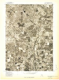
1976 Map of Onekama NE
USGS Topo · Published 1976About this map
Kaleva and the rural crossroads of Pleasanton anchor this 1976 orthophoto study of Manistee County, capturing the agricultural and woodland patterns of Northwest Michigan during the mid-1970s. This advance print, derived from aerial photography taken in May of that year, provides a literal visual record of the land surface, revealing the sharp contrast between dense woodlots and cleared fields. The Betsie River snakes through the northern portion of the landscape, its corridor defined by darker riparian vegetation. Unlike traditional line-drawn maps, this photo imagery shows the exact footprint of farmsteads and the grid of rural roads as they truly appeared on the ground, offering researchers a precise document of property use and residential development in this section of the Onekama NE quadrangle.
Find a feature on this map
3 named features on this map. Tap any name to fly to it.
Don’t see what you’re looking for? This feature index may not catch every label — zoom into the map to look around manually.
Map Details
Editions of this 1976 Onekama NE Map
This is the sole edition of this map. No revisions or reprints were ever made.
Other maps of this area

1954 · Traverse City
USGS Topo · 1:250,000

1954 · Manitowoc
USGS Topo · 1:250,000

1956 · Onekama
USGS Topo · 1:62,500

1956 · Thompsonville
USGS Topo · 1:62,500

1956 · Frankfort
USGS Topo · 1:62,500

1957 · Copemish
USGS Topo · 1:62,500

1958 · Traverse City
USGS Topo · 1:250,000

1958 · Manitowoc
USGS Topo · 1:250,000

1976 · Frankfort SE
USGS Topo · 1:24,000

1976 · Onekama SE
USGS Topo · 1:24,000