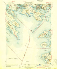
1941 Map of Onset
USGS Topo · Published 1942About this map
The intricate shoreline of Buzzards Bay dominates this coastal survey, revealing a landscape defined by narrow necks, sheltered harbors, and early 20th-century summer colonies. Along the northern reaches, the village of Onset and the neighboring Point Independence are densely mapped, showing a complex network of streets near Sunset Cove. The maritime character of the region is anchored by the Wings Neck Lighthouse and the Cleveland Ledge Lighthouse, while recreational life is evident at the Beverly Yacht Club and the Kittansett Golf Club on Sippican Neck. In Falmouth and Wareham, the transition from sea to land is marked by features like Stones Bog and the Agawam Cem. This 1941 revision details the established beach communities such as Pinehurst Beach and Silver Beach before postwar expansion altered the Cape Cod gateway.
Find a feature on this map
106 named features on this map. Tap any name to fly to it.
Don’t see what you’re looking for? This feature index may not catch every label — zoom into the map to look around manually.
Map Details
Editions of this 1941 Onset Map
4 editions found
Other maps of this area

1885 · New Bedford
USGS Topo · 1:62,500

1885 · Middleboro
USGS Topo · 1:62,500

1886 · Falmouth
USGS Topo · 1:62,500

1886 · Plymouth
USGS Topo · 1:62,500

1888 · New Bedford
USGS Topo · 1:62,500

1888 · Falmouth
USGS Topo · 1:62,500

1888 · Middleboro
USGS Topo · 1:62,500

1889 · Plymouth
USGS Topo · 1:62,500

1893 · Middleboro
USGS Topo · 1:62,500

1893 · Falmouth
USGS Topo · 1:62,500