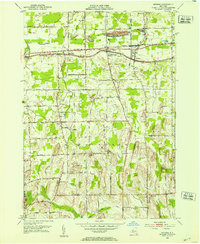
1952 Map of Ontario
USGS Topo · Published 1953About this map
Fruitland and Ontario Center sit along the historic Ridge Road corridor in the early 1950s, a landscape defined by the parallel tracks of the New York Central railroad and the rich agricultural drumlin topography of Wayne County. This survey, compiled from 1938 aerial photography and 1952 field work, shows a transition from the lakeside plains near Ontario toward the more pronounced drumlins to the south. Distinctive terrain features like Kuttruff Hill and Boyton Hill rise above the surrounding farmland, while local institutions such as Wayne Central Sch and the Ontario Golf Course reflect mid-century community development. Genealogists will find numerous family-named landmarks and resting places, including Furnaceville Cem and Walworth Cem, providing a window into the ancestral footprint of Walworth and its neighboring hamlets during this era of postwar growth.
Find a feature on this map
55 named features on this map. Tap any name to fly to it.
Don’t see what you’re looking for? This feature index may not catch every label — zoom into the map to look around manually.
Map Details
Editions of this 1952 Ontario Map
Other maps of this area

1899 · Palmyra
USGS Topo · 1:62,500

1900 · Macedon
USGS Topo · 1:62,500

1902 · Pultneyville
USGS Topo · 1:62,500

1902 · Palmyra
USGS Topo · 1:62,500

1932 · Webster
USGS Topo · 1:24,000

1932 · Fairport
USGS Topo · 1:24,000

1934 · Fairport
USGS Topo · 1:24,000
1934 · Ninemile Point
USGS Topo · 1:24,000

1934 · Webster
USGS Topo · 1:24,000

1942 · Ontario
USGS Topo · 1:31,680