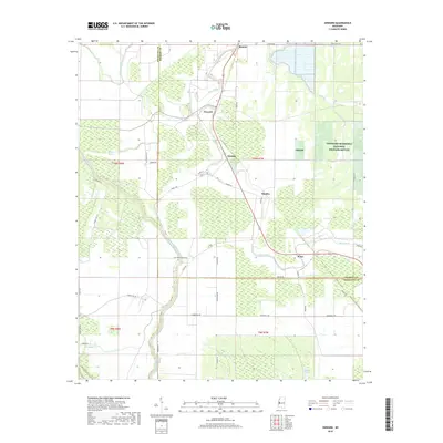
2018 Map of Onward
USGS Topo · Published 2018About this map
Theodore Roosevelt National Wildlife Refuge dominates the eastern reaches of this Sharkey and Issaquena County landscape, preserving a massive tract of bottomland hardwood habitat. The settlement of Onward sits at a central crossroads along Deer Creek, a primary waterway that meanders through the alluvial plain. This 2018 survey reveals a topography defined by complex hydrography, where remnants of ancient river paths appear as False River and Coon Bayou. Local infrastructure, including Low Water Bridge Rd and Atwood Rd, provides access to the agricultural lands and wetland basins that lie between the Steele Bayou and Newsom Bayou systems. The map further details the small communities of Blanton, Smedes, and Kelso, each situated near the winding course of the creek, illustrating the long-standing relationship between settlement patterns and the Delta's natural drainage.
Find a feature on this map
45 named features on this map. Tap any name to fly to it.
Don’t see what you’re looking for? This feature index may not catch every label — zoom into the map to look around manually.
Map Details
Editions of this 2018 Onward Map
This is the sole edition of this map. No revisions or reprints were ever made.
Other maps of this area

1939 · Onward
USGS Topo · 1:62,500

1939 · Lorenzen
USGS Topo · 1:62,500

1939 · Alsatia
USGS Topo · 1:62,500

1939 · Mayersville
USGS Topo · 1:62,500

1955 · Jackson
USGS Topo · 1:250,000

1961 · Jackson
USGS Topo · 1:250,000

1962 · Jackson
USGS Topo · 1:250,000

1963 · Onward
USGS Topo · 1:62,500

1964 · Lorenzen
USGS Topo · 1:62,500
1970 · Whiting Bayou
USGS Topo · 1:24,000