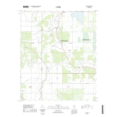
2020 Map of Onward
USGS Topo · Published 2020About this map
The delta lowlands of Sharkey and Issaquena counties define this landscape, dominated by the sprawling conservation lands of the Theodore Roosevelt National Wildlife Refuge. The map reveals an intricate hydrographic network where Steele Bayou and Deer Creek meander through a patchwork of wetlands and agricultural tracts. Small communities like Onward, Kelso, and Smedes are linked by a grid of rural roads such as Summerall Rd and Atwood Rd, reflecting the region's enduring rural character. The presence of features like False River and Newsom Bayou highlights the complex natural drainage patterns characteristic of the Mississippi Delta. This survey captures the intersection of federal wildlife management and local agricultural life as it existed in the early 21st century.
Find a feature on this map
43 named features on this map. Tap any name to fly to it.
Don’t see what you’re looking for? This feature index may not catch every label — zoom into the map to look around manually.
Map Details
Editions of this 2020 Onward Map
This is the sole edition of this map. No revisions or reprints were ever made.
Other maps of this area

1939 · Onward
USGS Topo · 1:62,500

1939 · Lorenzen
USGS Topo · 1:62,500

1939 · Alsatia
USGS Topo · 1:62,500

1939 · Mayersville
USGS Topo · 1:62,500

1955 · Jackson
USGS Topo · 1:250,000

1961 · Jackson
USGS Topo · 1:250,000

1962 · Jackson
USGS Topo · 1:250,000

1963 · Onward
USGS Topo · 1:62,500

1964 · Lorenzen
USGS Topo · 1:62,500
1970 · Whiting Bayou
USGS Topo · 1:24,000